For the second time in a month and the 21st time this year the Philippines is battered by a typhoon: Typhoon Phanfone has left 16 dead with 30,000 stranded of evacuated

Hurricanes and Cyclones 2019: Millions evacuated or homeless: Thousands dead and islands destroyed forever: Super Typhoons record breaking hurricanes bring devastation this year

Just 54 days into 2019 and we had a super typhoon!
Typhoon Wutip was the strongest February storm seen in the western Pacific Ocean in 70 years. On Feb. 23 2019, Wutip became a rare February super typhoon – just shy of Category 5 strength – with sustained winds of 155 mph, only three other February storms in the Northwest Pacific basin have reached at least Category 4 intensity since records began in the 1940s.
Millions of people were affected by the deadly storm caused by cyclone Idai
In March, the deadly Tropical Cyclone Idai rapidly strengthened to a Category 3 storm in the warm waters of the Mozambique Channel. The Joint Typhoon Warning Center said the storm had sustained winds of 120 mph, the storm did strengthen to a Category 4 storm with winds near 145 mph.
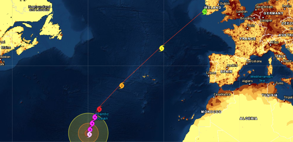
For the 21st time this year the Philippines prepare for a typhoon! Typhoon Phanfone expected to make landfall on Xmas day: Monster Typhoon Kammuri killed ten earlier this month

For the second time in a month, the Philippines are in the sight of a typhoon. Typhoon Phanfone is forecast to gradually strengthen as it churns westward toward the central Philippines, where it could pose a typhoon threat over the Christmas holiday. Phanfone is locally known as Ursula in the Philippines. Weather Wunderground Typhoon Phanfone will be the 21st tropical storm to enter the Philippines this year.
Three Tropical Cyclones Stalk Eastern Africa: Tropical Cyclone Ambali has rapidly intensified and reached the equivalent of a strong Category 4 hurricane

or tropical cyclones, as they are called in that part of the world.
The strongest of the three, Ambali is rapidly intensifying by 115 mph wind-speeds in 24 hours, making it the most rapid intensification in a 24-hour period in the Southern Hemisphere by a named storm on record and the second most rapid intensification globally. Ambali is at this moment, the equivalent of a strong Category 4 hurricane and is south of the Equator and east of northern Madagascar. Ambali is not expected to threaten land before dissipating.
The Indian Ocean is putting on a show: Five (5) tropical systems have developed: The storms are forecast to erupt this week across the Indian Ocean

The storms are forecast to erupt this week across the Indian Ocean with torrential downpours, damaging winds and dangerous swells a possible result of the storms. NASA's Aqua satellite found some powerful storms in Tropical Storm 06A as it moved through the Arabian Sea toward Somalia.
Around 350,000 people in evacuation centres along with 10 dead and many missing: Powerful Typhoon Kammuri leaves a trail of disaster as it exits the Philippines

The death toll from the monster Typhoon Kammuri that hit provinces south of the Philippine capital Manila rose to 10 with many missing, disaster agencies said on Wednesday, pointing to precautions and compulsory evacuations as key in preventing more casualties. Winds gusting up to 200 kph (124 mph) damaged homes and structures and tore down trees and signage as it barreled through central islands south of the capital
Typhoon Kammuri, known locally as Tisoy has rapidly intensified and is expected to reach "Super Typhoon Status" with the Philippine capital Manila in her sights

Typhoon Kammuri to reach at least a Category 3 and could reach Super Typhoon status: Expected to make a severe impact on the Philippines Monday

The centre of Typhoon Kammuri was located near Latitude 13.5 degrees North and Longitude 134.7 degrees East. Typhoon Kammuri is moving west-southwest at 10 mph. It is expected to make a slight turn toward the west with a slight increase in forward speed through Sunday. The current forecast track will take Kammuri into the Northern Philippine area by Monday with the capital city Manila expected to take a direct hit with Typhoon Kammuri expected to reach at least a Category 3 and could reach Super Typhoon status.
Two million evacuated as Cyclone Bulbul smashes into the Bay Of Bengal while Vietnam prepares for Tropical Storm Nakri landfall tonight

According to Reuters, several coastal districts were expected to register wind speeds of up to 120 kilometres per hour (74.5 miles per hour) and heavy or very heavy rainfall, the Bangladesh Meteorological Department said in its latest forecast. It said low-lying areas and islands were likely to see storm surges between five and seven feet (1.5-2.1 meters) higher than normal maximum tide levels.
Fukushima area flood water reached as high as 75 feet, (23 metres) and mudslides hit 150 locations with more heavy rain forecast in the coming days

Fukushima region hardest hit by typhoon Hagibis as radioactive soil is being pushed from the mountains down into areas where people live and crops are grown

Typhoon Hagibis horror! Thousands of bags containing radioactive waste have been washed into local Fukushima stream by floodwaters, leaving a devastating environmental impact

As Typhoon Hagibis hammered Japan on Saturday, thousands of bags containing radioactive waste have reportedly been carried into a local Fukushima stream by floodwaters, potentially having a devastating environmental impact. According to Asahi Shimbun, a temporary storage facility containing some 2,667 bags stuffed with radioactive contaminants from the 2011 Fukushima Daiichi nuclear disaster was unexpectedly inundated by floodwaters brought by Typhoon Hagibis. Torrential rain flooded the storage facility and released the bags into a stream 100 meters away.
It could be the strongest storm the country has faced since Kanogawa Typhoon in 1958: Typhoon Hagibis disrupts Rugby World Cup and Formula 1

Authorities have issued evacuation advisories in areas at particular risk, while supermarkets are running low on stocks as people buy supplies before the typhoon hits. Hagibis, which means "speed" in the Philippine language Tagalog, is due to hit Japan on Saturday.
Super Typhoon Hagibis strongest storm on the planet: To become the strongest of the year: Most intensification by a tropical cyclone in the western North Pacific in 25 years

It developed from tropical storm to a monster Super Typhoon in just 18 hours and is set to become the biggest and strongest storm of this year. Hagibis is currently classed as "violent" -- the Japanese Meteorological Association, (JMA) highest classification, with gusts as strong as 270 kilometres per hour. According to Japan Today, Super Typhoon Hagibis is heading nearer Tokyo, Japanse most densely populated area, ahead of big the Rugby World Cup weekend and could affect several crucial games.
Record-breaking Hurricane Lorenzo morphs into a category 5 hurricane: The second Atlantic hurricane to reached CAT5 to impact the UK next week
Stench of death in some neighbourhoods of the Bahama Islands has become overwhelming: Police say they don't want to go there: 1300 still missing

According to the report by CNN, East Grand Bahama still looks like a war zone. The carnage is so widespread that even police officers can't bear to see it. "Police say they don't want to go there. It's too hard on them to go see their people," said Patricia Freling, a Florida nurse who's volunteering in East Grand Bahama.
"They think there will be a lot of bodies. So we are preparing for everything."
Disaster unfolding! Tropical Depression Imelda causing extraordinary threat to life and property in Texas with more intense rain in the forecast

"They are forming like roaches out there," NH Spokesman! Six Named Storms Line up at Once in Atlantic and Eastern Pacific Basins and Ties Modern Record

Tropical Depression Imelda could dump the heaviest rainfall Houston has seen from one storm system since Harvey. Imelda is moving slowly northwestward through eastern Texas, with heavy rain extending primarily to the south and east of its circulation centre north of the Gulf Of Mexico.
"Tropical Storm Nine" set to cross the battered northwestern Bahamas: Hurricane status is a possibility with 1,300 people still missing after Hurricane Dorian

The storm will come as bad news for the islands as most people are now living in tents and shelters, Reuters this morning claimed some 1,300 people are still missing, according to the Bahamian government, relief services are focused on search and rescue as well as providing life-sustaining food, water and shelter.
Bahamas: Prepare for unimaginable information: Actual death toll expected to be in thousands, 70,000 people need food and shelter, 6,600 people still missing

Dorian! Critical supplies sat undistributed: Some were stolen: Dollars didn't end up in the hands of the poorest and most in need, but with the politically connected and well off.

What you need to know! Four potential tropical depressions forming in the Atlantic and the Gulf as Hurricane Dorian becomes a multi record-breaker

While Hurricane Dorian Dorian's forward speed has slowed to a virtual stall near Grand Bahama Island. The eyewall has now been pummeling the island for more than 24 straight hours – since Sunday night. Unfortunately, that means the northwestern Bahamas – particularly Grand Bahama Island – are taking an extended pummeling from destructive winds and catastrophic storm-surge flooding. The National Hurricane Center is issuing advisories on Hurricane Dorian, located just north of western Grand Bahama Island.
Record busting Cat 5 Hurricane Dorian is confirmed the second-strongest Atlantic storm on record: Top sustained winds of 185 mph with gusts topping 220 mph (350 KMH)

She adds "It's devastating" but cautions that so far there is "luckily no loss of life reported. At 3 p.m. EDT Sunday, Dorian had top sustained winds of 185 mph with gusts topping 220 mph, according to the U.S. National Hurricane Center in Miami.
Hurricane Dorian to hit Florida as a category 4+ monster! Third straight year the U.S. has endured a landfalling major hurricane – a streak not accomplished in nearly 60 years

Hurricane Dorian began gaining power last night jumping from 85 mph (137 kmh) to 105 mph (165 kmh) and with higher wind gusts, making it a Category 2 storm on the 5-step Saffir-Simpson scale for measuring hurricane intensity, according to Reuters.
“Now it’s looking like it could be an absolute monster,” Trump said in a video posted on Twitter, adding that food and water were being shipped to Florida.
As we approach the peak of hurricane season Tropical Storm Dorian set to be named hurricane by Tuesday as it sets course to hit the eastern Caribbean

Tropical Storm Dorian is strengthening as it moves westward toward the Windward Islands where it will bring heavy rain and strong winds early this week and could reach hurricane strength by Tuesday.
Dorian is currently centred more than 200 miles east-southeast of Barbados, moving steadily west at 10 to 15 mph.
Japan hit with Biblical amounts of rain! Total rainfall could surpass 1200 mm (47 inches) in 24 hours which is more than 10 times their August average

Ladies and gentlemen, if I can put, "total rainfall could exceed 1,200 millimetres," into some kind of perspective, well 1,200 millimetres is more than 10 times the average Japanese rainfall for August and in ft and inches, weighs in at nearly 4ft or 47 inches, which of course is well over 1 metre.
According to Reuters, heavy rains lashed parts of western Japan on Thursday as tropical storm Krosa made landfall, forcing the cancellation of hundreds of flights and trains as authorities advised more than half a million people to evacuate.
Hat-trick! Krosa will be the third storm to hit Japan in only 10 days after super typhoon Lekima hit late last week and typhoon Francisco made landfall on Aug 6

More than a million evacuated as Super typhoon Lekima smashes into China's East coast as it approaches Shanghai with a population of 20 million

More than a million people have been evacuated as Super typhoon Lekima smashes into eastern China Saturday
At least 13 people have so far been killed and 16 were reported missing in eastern China on Saturday in a landslide triggered by the major typhoon.
According to the BBC, Lekima made landfall in the early hours of Saturday in Wenling, between Taiwan and China's financial capital Shanghai. The storm was initially designated a "super typhoon", but weakened slightly before landfall - but still had winds of 187km/h (116mph).
Monster! Super typhoon Lekima strongest since 2014 is battering Taiwan with winds of more than 190km/h (120mph) is expected to make China landfall on Saturday

Lekima increased its strength yesterday to super typhoon status.
Super typhoon Lekima, the strongest since 2014, was expected to hit the mainland early on Saturday and then turn north.
The National Meteorological Center (NMC) has issued gale warnings for the Yangtze river delta region, which includes Shanghai.
Typhoon Lekima is currently battering Taiwan with winds of more than 190km/h (120mph) According to Reuters, Taiwan has already cancelled flights and ordered markets and schools to close on Friday as the typhoon heads northwest, cutting power to more than 40,000 homes and forcing the island’s high-speed rail to suspend most of its services.
The Calm Before The Storm! Trio of Tropical Storms in the Western Pacific lining up set to become typhoons after unusual quiet period

A triangle of tropical storm systems in the Western Pacific Ocean was seen by Japan’s Himawari-8 satellite on Tuesday, August 6, 2019, breaking a period of unusually calm storm activity in the region according to the Joint Typhoon Warning Center (JTWC).
To the north, is Tropical Storm Francisco, which made landfall in southern Japan as a typhoon early on Tuesday, August 6, 2019, local time, bringing heavy rainfall and strong wind gusts up to roughly 85 mph. It's now a tropical storm and is moving west to northwest toward the southern coastline of South Korea.
Hurricane season ramps up! Two Tropical Storms ( Erick and Flossie) Strengthening to hurricanes in the Eastern Pacific tracking west toward Hawaii

Tropical storm Erick has strengthened to hurricane category with sustained winds of 70 mph and is moving west at 17 mph.
The NHC predicts Tropical Storm Erick will continue tracking west toward Hawaii, attaining hurricane status today and potentially becoming a Category 3 hurricane within the next 2 days.
Meanwhile, the National Hurricane Center in Miami, Florida is issuing advisories on Tropical Storm Flossie, centred over 2400 miles east-southeast of Hilo, Hawaii.
Tropical Cyclone Fani is forecast to become a formidable cyclone in the Bay of Bengal as death toll rises to 38 in Mozambique from Cyclone Kenneth

Cyclone Fani is expected to intensify into an “extremely severe” storm as it heads toward the coast of the eastern Indian state of Odisha, the India Meteorological Office said on Tuesday.
According to Reuters, the storm is currently in the Bay of Bengal about 690 km (414 miles) east-southeast of Chennai and moved north-northwest at a speed of 16 km per hour (10 miles per hour) over the past six hours, the office said.
Weeks after a 1,000 people were killed by Cyclone Idai Tropical Cyclone Kenneth is barreling toward Mozambique and could be the strongest storm ever recorded there

Kenneth will be the first tropical cyclone with the equivalent of hurricane strength to strike Mozambique's northern province of Cabo Delgado since modern record-keeping.
Kenneth has undergone rapid strengthening as is now an intense tropical cyclone with its strength equal to a Category 4 hurricane in the Atlantic or eastern Pacific oceans.
Hundreds of thousands of people are still in need of aid after Cyclone Idai battered Mozambique, Zimbabwe and Malawi in March, according to Accuweather.
Cyclone sandwich! Two powerful cyclones Trevor and Veronica both expected to make landfall this weekend in northwest and northeast of Australia

Two powerful cyclones have sandwiched northern Australia and both are expected to make landfall this weekend.
Tropical Cyclone Trevor will make its second landfall this weekend in the northeast after strengthening, with winds expected to reach almost 100 mph.
Evacuations have already occurred and an emergency was declared in parts of the Northern Territory.
On the northwestern part of the country, a very powerful Tropical Cyclone Veronica will also make landfall during the weekend.
The death toll has risen to more than 500 as tens of thousands still awaiting rescue with time running out for Cyclone Idai victims

The full scope of devastation across three African nations may not be known for some time after the Cyclone Idai death toll surpasses 500; While tens of thousands are still awaiting rescue and rescuers fear time is running out.
Officials are claiming the death toll has risen to 242 in Mozambique.
In Zimbabwe, Defense Minister Oppah Muchinguri told the Associated Press that more than 120 bodies were washed into Mozambique by the flooding, bringing the death toll in Zimbabwe to at least 259.
Cyclone Trevor: Largest ever evacuation under way in Australia's Northern Territory as a state of emergency declared

The largest evacuation before a cyclone in Australia's Northern Territory history is underway as Cyclone Trevor takes aim, to make landfall on Saturday.
Already in 2019, Australia has suffered its hottest January ever the wettest February ever the hottest start to Autumn in 30 years the hottest March heatwave in 52 years and now Australia's Northern Territory is set to be battered by the strongest cyclone since 2015.
300 dead Zimbabweans have floated into Mozambique as death toll rises and nearly 2 million people affected from Tropical Cyclone Idai

Some have floated all the way into Mozambique and some of the peasants in Mozambique were calling some of our people saying that ‘we see bodies, we believe those bodies are coming from Zimbabwe.
The total number we were told there could be a hundred, some going as far as saying there could be 300 but we cannot confirm this situation; our army is going on foot to Rusitu in order to go and assess the situation on the ground.
Up to a 1,000 thought to be dead with fears for another 500,000 as 90% of the Mozambique city of Beira is destroyed by Cyclone Idai

Fears are growing for more than 500,000 people in the Mozambique city of Beira after aid agency officials warned that 90% of the area had been "destroyed" by Cyclone Idai.
The cyclone slammed into the southeast African country as a high-end Category 2 storm with 175 kph (110 mph winds) at midnight Thursday, causing widespread devastation, before moving inland into Zimbabwe and Malawi.
According to the BBC, the storm made landfall near the port city of Beira on Thursday with winds of up to 177 km/h (106 mph), but aid teams only reached the city on Sunday.
The deadliest weather disaster of 2019 Cyclone Idai death toll reaches 200 affecting 250,000 people death count expected to rise

According to Reuters, the scale of destruction is only becoming apparent as rescuers reach the most affected areas, near the border with Mozambique.
Torrential rains and winds of up to 170 km per hour swept away roads, homes and bridges and knocked out power and communication lines and impacting 250,000 people.
Tropical Cyclone Idai is the deadliest weather disaster of 2019 killing 111 and impacting nearly 150,000 in Mozambique and Malawi

The initial system killed at least 66 people due to flooding in Mozambique, Agence France-Presse reported.
Flooding has also destroyed more than 5,700 homes and impacted more than 140,000 people in the southern African country.
Flooding from the storm has already inundated nearly 650 square miles, destroyed 18 hospitals, 938 classrooms and injured more than 100 people.
Tropical Cyclone Idai set to be the fourth strongest since satellites records began with winds reaching nearly 150mph in the Mozambique Channel

Six people died in the central Tete province in recent days while four were swept away in the coastal Zambezia province, the UN Office for the Coordination of Humanitarian Affairs said in a report.
More than 62,000 people have so far been affected by floods in the two provinces as well as in the northern Niassa province.
"At least 10 deaths reported, and 62,975 people were affected by the floods," the UN said.
Super Typhoon Wutip the strongest February storm seen in the western Pacific Ocean in 70 years

Typhoon Wutip, the strongest February storm seen in the western Pacific Ocean in 70 years, passed south of Guam and may brush the northern Philippines later this week. This visible imagery, captured by Japan's Himawari-8 geostationary satellite on Feb. 25, 2019 (12:35 a.m. ET), shows Wutip's distinct eye as it churned through the Pacific.
On Feb. 23, Wutip became a rare February super typhoon – just shy of Category 5 strength – with sustained winds of 155 mph. According to NOAA's Historical Hurricane Tracks database, only three other February storms in the Northwest Pacific basin have reached at least Category 4 intensity since records began in the 1940s.